OceanGrafix — Accurate Charts. Confident Boating.
ANNOUNCEMENT
All NOAA charts have been cancelled. NOAA will maintain and support ONLY the ENC database for navigation. For the full NOAA explanation, go HERE:
https://nauticalcharts.noaa.gov/charts/farewell-to-traditional-nautical-charts.html
OceanGrafix will print the legacy chart number and area pulling the navigational data from the ENC database. However, the scale of the traditional NOAA Chart number and area do not always coordinate with the scale in which the data needs to be represented, particularly for harbor or shoreline readability.
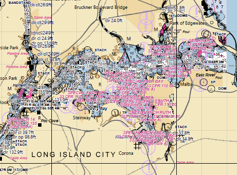
For example, the traditional (raster) NOAA 12363 chart was at a scale of 80000, but the ENC data in the East River area is surveyed at a scale of 10000, making the data in the East River unreadable:
The NOAA Custom Chart (NCC) application enables users to create their own customized nautical charts directly from the latest official NOAA electronic navigational chart (NOAA ENC®) data.
Q: How do I use the NOAA Custom Chart Creator?
A: An updated User Guide was released with NCC version 3.0. This explains how the various application settings work and provides tips for creating the best customized charts. There is also a video that explains the basics of creating a custom chart and using the new personal chart catalog feature. Other resources are also available in the NCC Help & Feedback panel.
Q: How to print an NCC chart that I made?
A: Send your NCC pdf to an OceanGrafix Agent for printing, or online HERE.
Q: How do I correct my chart?
A: To find your chart corrections, go to the Navigation Updates site:
https://distribution.charts.noaa.gov/navigation-updates
Q: How do I know when to update my NOAA Custom Chart?
A: You can save custom chart parameters—scale, paper size, extent, etc.—in a chart catalog GeoJSON file. The file can then be inputted into the online NOAA Navigation Updates application to determine if any of the NOAA ENC data used by NCC to create the chart has been updated since the chart was last exported.
The NOAA Navigation Updates website identifies critical corrections published in the Local Notices to Mariners that have been applied to the NOAA ENC data, as well as routine non-critical corrections that are regularly released in NOAA ENC revisions. The application displays corrections in a map and provides textual information about each correction. Charts in the catalog are tagged as either having updates "available" or "none." Charts with updates available can easily be re-exported in the NCC application with the latest ENC data applied.
Q: I have a problem or comment for the NOAA Custom Chart Creator.
A: For further assistance or to suggest improvements for the NOAA Custom Chart application, questions or comments may be submitted through the Coast Survey's online ASSIST customer feedback tool.
Q: Do NOAA Custom Charts meet USCG paper chart carriage requirements for regulated vessels?
A: The U.S. Coast Guard has asked that questions and comments regarding nautical chart carriage requirements be directed to the U.S. Coast Guard Navigation Center at:
https://www.navcen.uscg.gov/contact/contact-us
Q: Why did NOAA end traditional paper nautical chart production?
A: There is a growing demand for ever more detailed nautical charts. To help meet this need, NOAA initiated a program to sunset its traditional paper nautical charts and the corresponding raster chart products and services. This has enabled NOAA to focus on improving the coverage and content of the digital chart format that is used throughout the world for navigation, namely the electronic navigational chart (ENC). ENC data is produced by over twenty other countries and used by mariners around the world.
Producing and distributing raster charts requires additional, separate computer software and data storage, as well as specialized cartographic training and processing beyond the resources needed to maintain ENCs alone. NOAA is carrying out an ambitious program to replace much of the existing NOAA ENC coverage with more detailed (larger scale) data. When completed, the enhanced product suite will consist of over 7,300 ENCs in twelve standard scales. NOAA has only been able to create and maintain this enhanced suite of ENC products by redirecting resources previously used to update and distribute traditional paper and raster nautical charts.
Q: Will the last editions of traditional NOAA paper charts still be available?
A: Yes, OceanGrafix will keep the last edition available for reference. Canceled charts do not meet U.S. Coast Guard carriage requirements for regulated vessels and should not be used for navigation.
Q: Can I order a chart directly from your site?
A: Should you choose to initiate your order from the OceanGrafix web site, you will be automatically directed to one of our retailer sites for the completion of your transaction.
Q: How do I know how much shipping will cost?
A: If you choose to purchase your chart online, you will be directed to one of our online retailers. Shipping and handling fees vary according to the retailer.
Q: Who can I contact with questions or problems regarding my order?
A: In most cases the retailer from whom you purchased your chart will best be able to help you. However, an OceanGrafix representative will always be happy to assist you as well. Contact us.
Q: Am I legally required to have nautical charts onboard?
A: While commercial mariners are obligated to have up to date navigational charts on board, recreational mariners are not required to do so by law. However, virtually all boating experts agree that paper charts are critical to boating safety — for all mariners.
Q: I have GPS onboard. Why do I need a paper chart?
A: Unfortunately, GPS and other electronic systems are not foolproof. A paper chart serves as important backup when the unexpected happens.
Q. What is OceanGrafix’s relationship with NOAA?
A. In June 2000, OceanGrafix was selected as NOAA’s partner in the development of a new generation of nautical charts for U.S. waters. Using digital technology, OceanGrafix is able to continually incorporate NOAA’s latest cartographic changes — and then print these fully up to date charts as they are ordered. The new charts were first introduced in 2002, and OceanGrafix continues to produce them today under an exclusive contract with NOAA.
Q: What are NGA charts?
A: National Geospatial-Intelligence Agency (NGA) charts cover a variety of international waters worldwide. Previously discontinued in the spring of 2010, OceanGrafix now prints over 3000 of these charts for commercial and recreational boaters.
Q: NOAA uses the term “Print on Demand.” What does that mean?
A: “Print-on-Demand” refers to NOAA’s exclusive arrangement with OceanGrafix to print NOAA charts that are 100% up to date when they are ordered by a customer. OceanGrafix charts are printed (and shipped or picked up at an OceanGrafix retailer) only when an order is placed.
Q: How do I know which charts I will need?
A: To locate charts by geographic region click on search charts, and then use "search by map" to help identify which chart numbers you need based on the areas you choose.
Q: How do I purchase OceanGrafix NOAA charts?
A: You can call or visit any of the chart retailers in our U.S. network. Many of them are designated as “remote printers” and can print your chart immediately. Most OceanGrafix retailers also have websites and some offer catalog sales. You can also purchase OceanGrafix charts online.
Q: How do I find a retailer in my area?
A: Our website allows you to simply browse or enter your state to find a retailer nearest you.
Q: What Size are the Charts?
A: The full-size OceanGrafix NOAA chart is a single-sided product available in size from approximately 3' to 5' in length and are either 36" or 42" wide, depending on the coverage needed for each specific geographic area.
Q: What Are The Charts Printed On?
A: Charts are printed on standard paper or a fully waterproof synthetic material, vessels with adequate bridge space are able to extend the chart to full length, while vessels with smaller bridges have the option to fold the paper chart to the size they require (waterproof charts can be rolled & bound) for stowing.
Q: What do various “chart scales” mean?
A: Charts are created in different scales, with increasing levels of detail. For example, on a 1:80,000 scale chart, one inch on the chart represents 80,000 inches in the real world. In other words, one chart inch equals about 1.1 nautical miles. A 1:40,000 scale is twice as detailed. A small scale chart, say 1:200,000, covers a wide area but with less detail (since most charts are printed on similar sized sheets of paper).
Q: What is the purpose of a small-scale chart?
A: A small-scale chart, like a 1:1,000,000, is useful for planning long voyages, but provides little detail along the way. While they make terrific art for your walls, small-scale charts are among those you could consider skipping for your boating trip.
Q: What do you recommend for writing and erasing on OceanGrafix POD charts?
A: The Staedler pencils and erasers are highly recommended.